With all that considered, we drove 3681.7 miles over 8 days (average 460 miles per day) and had sufficient time to do all sightseeing we wanted to do. Except for Grand Canyon, all other experiences were new - in fact, many of them I had never heard about until I started planning this trip. Sources were: NPS (National Park Service), Nerd Trips, and "Top 10 things to do near ____."
Here is the final itinerary:
To view photos, click on the link to each attraction below.
- Day 1 Palmdale, Joshua Tree (12/22/16, 573 miles) - A long driving day to start off the trip - with a short stop at Palmdale and 2-3 hours at Joshua Tree NP at the end. Normal driving directions to Joshua Tree (and on to Phoenix, Tucson, El Paso, and beyond) are to drive down I-5 up to Los Angeles and then take I-10 all the way. That of course meant a chance of getting stuck in LA traffic somewhere, regardless of the time of the day. There is a better way.
- To reach Palmdale, you exit I-5 near Gorman (just past Tejon Pass at 4160 ft), bypassing LA traffic almost entirely - and without adding much distance or time to the trip. CA 138/14 move at 65 mph and have hardly any traffic - except for some small towns along the way. After exiting I-5, we expected a steep decline going to Lancaster/Palmdale similar to when going to LA. To our surprise, it stayed fairly flat rest of the way. Palmdale has elevation of 2657 ft.
- What's in Palmdale? San Andreas Fault that cuts Hwy 14 near Exit 33 to E Ave S (N34.562649 / W 118.132457) - the description said "drivers will glimpse frozen crashing waves of rock, revealed by a roadcut on Highway 14. The undulations mark the San Andreas Fault, sliced open by California highway engineers and laid bare for the geologically curious on the western edge of the cut. (For interactive map: http://www.thulescientific.com/san-andreas-fault-map.html) - We drove on Hwy 14 S past the cut but didn't notice it. We then took the next exit - E Ave S and parked in the Park and Ride lot next to Lake Palmdale. Later on, when we zoomed in to the map above, we realized that the Lake was right on the fault line as well, though not showing any other obvious signs. We returned the same way on the last day and were able to capture this photo.
- Joshua Tree National Park (NP, elev. 3000 ft) - Hwy 138 continues on to I-15 S. Then taking I-215 S and the I-10 E up to Exit 168 brings you to the South entrance of the Park. Our plan was to see as much of the Park today as we could, hopefully reaching Keys View for sunset and then stay overnight in Twentynine Palms on the north side. - What had started out as a nice clear day, had turned smoggy around Bakersfield and then cloudy / drizzly by the time we reached the Park. Knowing that we were visiting many National Parks during the next seven days alone, $80 America the beautiful Annual Pass was the way to go. The park ranger at Cottonwood gave us suggestions on what to see along the way and doubted any visibility at Keys View for sunset. He was right. - Ocotillo Patch, Cholla Cactus Garden, Jumbo Rocks, Skull Rock, Hall of Horrors and a large swath of gently sloping plateau with as many as 700 thousand Joshua Trees are all by the main road through the park going northwest. Plenty of campgrounds are along the way - this park sees more activity during winter-spring than summer (too hot!) We were close to Keys View around sunset, and the sky was cloudy but with decent visibility. As we started driving up to Keys View, however, fog rolled in completely covering the entire area. Clearly, there would be no views today. Forecast was for the same next morning, so we didn't even try. On our return one week later (12/29), the sky was perfectly clear and sunny, and we got our views of Salton Sea and Mexico beyond, San Jacinto Mountains, Palm Springs and San Andreas Fault in front.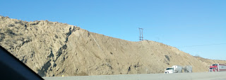
San Adreas Fault in Palmdale, CA - Day 2 Meteor Crater (12/23, 477 miles) - Another long day with the goal of reaching Meteor Crater (elev. 5710 ft), the only item on the agenda for the day, by 2 PM Mountain Time. Taking back roads and National Trails Highway, we reached I-40 in mere 89 miles. I-40 here is the old historic Route 66.
- The day was sunny/partly cloudy with light clouds floating by. Yet, all along I-40 we saw flashing signs warning Winter Storm Watch to motorists. (We had seen park rangers place snow/flooding signs at Joshua Tree the previous day, and had wondered.) It was smooth sailing for us, and we reached Meteor Crater as planned.
- Meteor Crater is privately owned, and tickets are pricey ($18), but is worth one visit. At the ticket counter, they told us that we just missed the last tour for the day (2:15) but we could do the self guided picture taking near the designated 3 lookout points, watch the movie and visit the museum. Excellent plan for students and children, but I was disappointed. We took pictures from the rim, looked through telescopes on the viewing platforms to the bottom of the crater 500 ft deep and a mile across, and returned to the theater to watch documentary at 3 PM.
- As we exited the theater after the movie, a female tour guide was waiting by the Holsinger meteorite (the largest discovered fragment of the meteorite that created Meteor Crater, 1400 pounds) and asked if anyone was interested in a guided tour on the rim of the crater. I definitely wanted to go, but they needed a minimum of 3 people to have the tour. None of the kids from the theater, nor their parents, were interested, but we found 3 men ready to go. Per their rules, if the tour guide was the opposite gender than the tour participants, another tour guide of that gender must also join in. So we had a male and a female tour guide for 3 male participants.
- The tour lasted one hour and went about half a mile West of the Visitor Center and back. The doors to the museum are locked behind us, and the group must stay together the entire time. In the past, they offered guided tours down to the bottom of the crater, but no longer. It was cold and windy, but walking around the rim was enjoyable. Along the way, we learnt a lot about the history, prior owners, current research and so on. Daniel Barringer and others drilled unsuccessfully at the bottom of the crater looking for the iron-meteorites as a business venture. None was found.
- We finished before sunset and headed back to Williams for overnight stay. San Francisco peaks near Flagstaff were the only ones with snow - as of today. That was going to change tomorrow. Forecast for Flagstaff was 7-14 inches of snow by tomorrow night. Much of the area, including Williams and Grand Canyon, was under Winter Watch from 11 am to 11 PM next day. If the forecast held, and if we managed to stay ahead of the storm, which was coming directly from the South, our plans would work out. It did. - Day 3 Grand and Glen Canyons, Lees Ferry, Horseshoe Bend and Lake Powell (12/24, 253 miles) - As we left Williams at 7 am, snow flurries were just starting. Grand Canyon Village is 60 miles straight north on AZ-64 N (South Rim, elev. 6400 ft.) We were quickly able to get ahead of the storm. The sky was partly clear ahead of us. We reached the park at 8 am, parked the car and walked over to Mather Point. The canyon was clear at the moment and we could see Colorado river a mile below us. The sky was clear and sun was shining to the left of us, but cloudy / foggy on the right. We walked left to Yavapai Point following the sunshine. By the time we were done taking photos, fog had rolled in and covered the entire canyon. Snow flurries also started coming down really hard. We enjoyed a leisurely walk back to the car near the visitor center. There was no accumulated snow on the ground anywhere up to this point in our trip.
- We started driving East towards Desert View Watchtower about 25 miles away. The road was mostly clear with only some patches of snow in various stages of melting/freezing. Sky was partly sunny again, with some clouds / fog rolling in. We were also slowly climbing - to 7400 ft at Grandview Point and 7460 ft at Desert View point.
- At Grandview Point turnout, there was enough snow on the road, hardened overnight, to make car slide/skid at will. Thankfully, speeds were low and there were hardly any other cars. At the lookout point, watching every step was a must. Grandview, as the name suggests, is where the canyon is the widest, and the views to the East, North and West are most expansive.
- Moran Point, Lipan Point and Navajo Point give a similar but different view of the canyon. Navajo Point is the highest view point and is very close to Desert View Watchtower.
- By 10:20 am, still ahead of the approaching Winter Storm, we exited Grand Canyon NP and continued East on AZ-64 for another 60 miles before turning on US-89 N towards Glen Canyon. It was clear skies ahead as far as we could see.
- Glen Canyon begins at Navajo Bridge where Marble Canyon meets it on the South, and goes North up to Glen Canyon Dam /Lake Powell near Page, AZ. After taking US-89 N up to Bitter Springs, the left fork US-89A takes you to Navajo Bridge 14 miles later, rapidly descending to the bridge level. Turn right after the bridge, and drive up to Lees Ferry, a popular spot for boating and fishing. River runners start their journeys through Grand Canyon here.
- Returning back to Bitter Springs and continuing on US-89 N, left exit lane and prominent dirt road on the west side just before milepost 545 is for Horseshoe Bend - not to be missed. Large and small tourist buses shuttle tourists from Page, AZ, only 3 miles away. A large dirt parking lot then leads to a trail going uphill - a stream of tourists going and coming is visible at all times. At the top, about 500-600 ft away, you reach a gazebo with views in all directions. To the North, you see white mountains of Grand Staircase National Monument in Utah. Continuing downhill 1500 ft or so brings you to the edge of Horseshoe Bend - just follow the crowds.
- Horseshoe bend, because of its unique shape, is a sight to see/photograph. Open on all sides, people are everywhere taking in the beauty or photographing. The same front that brought snow to Grand Canyon, also pushed clouds all the way here. It was extremely windy and at times, hurled sand in our faces. After taking several pictures, we decided to return next morning around sunrise, when the skies were expected to be clearer and winds subdued. All pictures look so good that it is difficult to pick out just one.
- It was only 1;30 PM so instead of stopping at our hotel in Page, we continued a couple of miles beyond to Carl Haydon Visitor Center at Glen Canyon Dam. Normally, tours of the dam are available throughout the day. However, it being Christmas Eve, the visitor center had closed early - and would be closed on Christmas as well. We were able to take photos of the dam - a larger version of arch dam like Hoover Dam several hundred miles downstream.
- A short driving day, but lots of sightseeing - thankfully, the weather cooperated. At Page (elev. 4117 ft), our hotel room had Lake Powell views, though it had gotten fairly cloudy by now, and soon dark. - Day 4 Horseshoe Bend, Antelope Canyon, Navajo National Monument and Monument Valley (12/25, 382 miles) - We left the hotel at 7 am to drive back down to Horseshoe Bend for more photos, and reached Lower Antelope Canyon at Ken's Tours. This was one of those surprise finds that turned out to be the highlight of this trip. Navajo Nation covers four states AZ, NM, UT and CO - though primarily AZ, East of Grand Canyon. All our travel today, until we reach Chambers on I-40, will be within Navajo Nation. Navajo impose their own tax, and much of the landscape is red sandstone with flat plateaus with butte and mesas,
- When I first googled Antelope Canyon, ads for Upper Canyon popped up. They are most popular with tour groups. You sign up with a credit card hold, and preferably pay cash when you get there (currently, $40 + $8 Navajo Tax). After parking your car at the Tour Operator's parking lot, you are driven 5 miles in 4X4 vehicles on bumpy dirt roads to the start of Upper Canyon tour. After the tour, you are driven back to your car.
- Upper Canyons are A shaped - wide at the bottom and narrow at top - which allow for phenomenal photo opportunities and is very popular with professional photographers armed with SLR cameras and tripods, and who like to photograph sun rays. Times for non-photographers (commoners with mere phone cameras) are limited to certain times of the day. Best during bright clear, sunny days - mainly during Summers. The canyons are above ground into a ridge, fairly level and require very little walking.
- Lower Canyon are just off AZ-98 on the North side (near Lake Powell and Antelope Point.) You self-drive your car to the location, purchase tickets and begin tour. It does involve some walking and climbing stairs - some very steep. With a V-shape frame, Lower Antelope Canyon is half a mile long and 120 feet deep.
- One Navajo family has the rights to run tours in the Lower Canyon, and Ken and his sister have their shops next to each other. I booked the first tour of the day (9:20 am during winter) online with no payment due. Cash payment of $20 + $8 Navajo Tax was due at the site. You are advised to reach 30 minutes in advance (8:50 am) - we happen to reach there 10 minutes before that. They asked if we'd rather go on the 9 am tour. It was a clear day and going 20 minutes earlier would not make much difference in lighting. I don't like to wait anyways, so we signed up for the 9 am tour.
- We were asked to wait in the waiting area (restrooms and souvenir shop, of course.) Five minutes to go, and there were only 4 people in the waiting area. And then a whole bunch of people arrived. One group had two couples with 3 young children. Guess whose tour they were with?
- At 9 am sharp, they announced the tour and checked our tickets at the door before letting us out in the backyard. Several tour guides were standing some distance apart, we were directed to each. Ours was Guide #1 - a young Navajo student(?) with excellent English and no accent. Each group had about 10 people - we had 9. Immediately, we started walking to the entrance of the cave (slot canyon as they are called.) half a mile away. After walking back and up through the canyon, we'd exit right in front of the tour building.
- As the young children were getting their act together, we walked ahead with the tour guide for 10 or so minutes, and learned a whole lot about the canyon. As soon as the rest of the group joined us, we started down 5 flights of stairs - some were too steep and narrow and required us to climb down backwards. By the time the four parents guided their 3 kids down to the bottom, I was concerned about how the rest of the tour was going to be. However, once at the bottom, the kids were happy doing their own things. Their parents let us stay ahead which gave us plenty of time to take pictures.
- The guide was very familiar with the cave, lighting, as well as best camera settings and spots to take pictures from. He was also taking pictures for us from time to time. Without rushing (or being rushed by the group behind us), we were able to enjoy the tour thoroughly.
- In the end, we come out through a crack in the ground - looking at which from outside, we wouldn't have guessed what lay underneath. Just outside, our guide showed us dinosaur footprints in the sandstone - though they were washed out somewhat. It was barely 10 am and we had two fantastic experiences already.
- Antelope Point (part of Glen Canyon) was only 4 miles further north. We drove to see what's out there. A large empty parking lot and a boat ramp - to Lake Powell. Clearly, boating and fishing is the primary activity here during the season.
- Back on AZ-98 driving 60 miles East we reached US-160 East. A few miles later, a sign directed us to AZ-564, 9 miles to Navajo National Monument. This two-lane road was rough, gently climbing and had snow around. Although our lane was snow-free and the opposite lane was half covered with snow. Signs warned us that this road is NOT plowed - but that wasn't quite true. Navajo National Monument is managed by NPS (National Park Service) and THEIR roads near the monument weren't plowed. AZ-564 was maintained by the state/county and as we drove part of the way, snow-plows clearing the other side of the road went by - apparently, just for us. There were no cars around.
- Being Christmas day, the Visitor Center was closed, but we could walk/hike around on our own. We enjoyed white Christmas under sunny/partly cloudy skies. The temperature was below freezing (30 / 16 degrees) at elev. 7300 ft. The crunchy crisp snow had no footprints anywhere. A couple of short trails led from the Visitor Center, but they were all snowed in. Monuments at this site were also not the kind we saw in old westerns (buttes) and ones we wanted to walk/drive around. We doubled back to US-160 and continued East for another 20 miles to Kayenta. From here, we turned North on US-163 for another 20 miles to barely cross the Utah border and turn right back in to Arizona to reach Monument Valley Navajo Tribal Park Visitor Center 4 miles away. Being a Navajo park, not part of NPS, they charged their own separate entry ticket ($20) - more on that below.
- Forecast was sunny at Page, AZ - and it was so when we left this morning. Monument Valley forecast was partly cloudy, and as we were driving to it, skies were almost clear at times, some white clouds rolling through at other times, with some clouds definitely ready to unload snow. We were still at elevation of 5200 ft, and forecast was 34 / 19 degrees.
- After witnessing how quickly the weather has been changing in the last couple of days, we started taking photos at the first opportunity - and not saving to take them later. So we took a couple of photos of monuments by the roadside with near clear skies all around. Five miles later, a large dark cloud suddenly appeared overhead. Visibility dropped and snow flurries started coming down - though not quite sticking to the windshield. Assuming the worst, we debated whether to continue to Monument Valley hoping to beat the snow clouds (or give up and return like we did at Keys View in Joshua Tree.)
- We pushed forward and actually got ahead of that snow cloud - and back in to partly sunny skies. As we turned on the Monument Valley Road, the famous monuments appeared in the distance. Following the lead of another car parked on the side of the road, we stopped and took pictures while it was still clear. When we reached the pay gate, the booth was closed ("Back at 1:30") but we could continue on.
- Strategically located Visitor Center and adjacent hotel have magnificent views right in front of them. A large balcony on one side of the Visitor Center provides perfect "Kodak Moment" photo spot. It started snowing just as we got out of the car, and minutes after taking a few photos from the balcony, fog rolled in making all monuments disappear.
- The park offers some walking / driving self-guided tours, but looking at the weather outside, we abandoned that plan. It was 1 PM and we had nearly 4 1/2 hour drive ahead of us to a small town middle of nowhere - Springerville, AZ.
- By the time we returned to Kayenta and filled up gas, the skies were clear again. Continuing 6 miles East on US-163, we took Navajo County-59. These smaller roads were all in excellent shape and had speed limits of 65 mph - and hardly any traffic. You get to see the countryside that you otherwise won't. All is well, as long as you don't have car troubles - we didn't.
- Arizona has some interesting town names - like Rough Rock, Many Farms, Sore Finger. At Many Farms, we took US-191 S for nearly 200 miles, including a 6 mile rendezvous with I-40 midway. The entire road was pretty lonely, with snow on the sides (but not the pavement) most of the way AND from time to time, snow clouds reminding us that this was winter after all. Low visibility and snow flurries would slow us down a bit, but then skies would clear again. - We soon realized that it was Christmas Day, and restaurants and grocery stores may not be open, or close early. We started calling around, but the phone reception was spotty. Our best chance was to find something on I-40. The only Subway in the area was 10 miles West and may not even be open. At the I-40 Chambers exit, there was a gas station, which was open, a Days Inn next door (also open) and adjacent restaurant with OPEN sign on. Well, thank goodness! I went in to check if it was in fact open. One sole person was sweeping the floor and informed us that it was closed at the moment, but will open in an hour. If it took us an hour to eat and then another hour drive down to Springerville - that's too much time wasted. Besides, it would be dark by the time we reached. We decided to march on.
- Reaching Springerville, just as it was getting dark, we were prepared to live on cookies and crackers for the night. The hotel was practically empty - so was the town. Hotel was owned by an Indian. The lady (wife) checked us in. Breakfast was included from 6 am next morning, but there was nothing for the night. I asked if any restaurants would be open - she doubted it because the entire town had Christmas dinner that night. Still, she called 3-4 places - no one picked up the phone.
- Minutes after we settled in the room, the husband called and inquired where we were from, etc. He offered to have his wife/mother-in-law cook an Indian dish for us - we couldn't refuse. A few minutes later, we had hot and spicy homemade Pohe (flattened rice) for dinner. I wrote a nice thank you note for the owners, and gave a great review on TripAdvisor. - Day 5 VLA, White Sands Missile Range and National Monument (12/26, 421 miles) - Another long day, starting and ending with driving. Because most things are/were closed for Christmas (exception: Navajo Parks and some National Parks like Grand Canyon), we had to make a northerly detour for the past couple of days, to this otherwise southerly trip. Everything will be open from now on.
- First stop was VERY LARGE ARRAY(VLA) (N 34 078700 / W 107.618251) about 111 miles away. I tried to get a hotel closer to VLA like in Socorro, NM, but that would have meant additional 2 hours of driving the previous day and returning one hour this morning.
- Good news was that the bad weather (though we were able to avoid most of it) was behind us now. It would be sunny / partly cloudy for the rest of the trip, with temperatures warming up as we drove further south. However, it was 7 degrees in Springerville when we left this morning. Luckily, we had parked the car under a tree so the windshield was clear - no scraping needed.
- We left Springerville at 6:15 am after having light breakfast. Taking US 60 from our doorsteps, we drove about two hours East to reach VLA at 8 am when they open. Unlike yesterday, the sky was completely clear and we could witness beautiful sunrise, which soon became blinding until the sun rose further up.
- In case you just want a picture of the telescope without visiting VLA, there is one "parked" right next to the road on US 60 with a pullout for you to take a photo from.
- VLA is a 20-mile-wide collection of 27 radio telescopes trained permanently on the skies above. Astronomers have used the glinting white receiving dishes to make discoveries for decades—including ice on Mercury and microquasars. Although radio telescopes can "see" much farther in space and capture much weaker signals, quality of the images from a single 82' telescope - as large as the largest glass/mirror optical telescope - is not that great. By spreading 27 of them in four different patterns A through D - A being the most closely clustered and D being farthest apart, it can mimic a 20 mile diameter giant telescope to focus on a single object. Furthermore, radio telescopes - unlike their optical counterparts - can function during the day, not just nights. Being on a lake bed with low humidity and away from city interference, they operate 24X7 - year round. The data is then fed to giant computers in Socorro, NM 50 miles away. I'm sure astronomers studying the data are also happy working at their own desks instead of staying up at nights at an observatory in the middle of nowhere.
- Goes without saying that VLA has minimal staff. We only saw one pick up truck drive by, and the cashier at the Gift Shop.
- The visitor center opened at 8:30 and gift shop at 9 am. But the door was open and all the displays and videos were working, so we familiarized ourselves with the place. A 5-minute silent video explained how antennas are moved
- Near the back door a brochure to guide you on the walking tour could be found (or just follow the signs) - Radio Sundial, Whisper Dish Gallery, on to Radio Astronomy Gallery, and finally to the base of one of the 230-ton working antenna on the array!
- From there, you head toward the control building to climb up to the observation deck for a view of the array itself and read details about the supercomputer processing taking place in the control building.
- Upon return, we watched the documentary - overview of radio astronomy, interferometry, and the VLA itself. (just push the green button on the wall to start the movie.)
- By the time that was over, it was after 9 AM and the gift shop was open. The cashier was more than happy to collect our money ($5 pp with AAA), and we were on our way. Ours was the only car in the lot the entire time.
- We were suggested to make a right-hand turn as we left the Visitor Center parking lot and head for the tall yellow building, following the signs for the AAB (Antenna Assembly Building) Tour. After the railroad track, there is a parking lot on your left. From there you may view the 28th antenna that may be undergoing routine maintenance. You may also see one of the transporters that is used to move the antennas. Being the day after Christmas, we didn't see any activity there.
- Continuing 50 more miles on US 60, we reached Socorro (VLA - Karl Jansky falls in Socorro city limits and have their actual research center and computers in Socorro itself.) Back on a freeway (I-25 S) with 75 mile speed limit, we drove a couple of hours to Exit 6 for US-70, just outside Las Cruces. We will return to Las Cruces on I-10 tomorrow on the way back. - White Sands Missile Range Museum - See http://www.wsmr-history.org/ for more about this active Missile Range, where they stop traffic on US-70 when they are testing missiles. There were no testing scheduled for this week.
- 20 miles on US-70 and then 3.5 miles on NM-213, you dead end at the check point. Park in the small parking lot and walk to the checkpoint with your ID. There were 6-8 people (3 families) ahead of us. As soon as he saw us coming, the security guard asked what we were there for (answer: museum), took our IDs and told us to wait a few minutes. It certainly took a few minutes to process our paperwork, and then he brought us official looking embossed entry permits. We then walked past the barriers, one block down to the Museum. All rockets and missiles that were tested at this site, as well as other equipment was displayed on the open grounds with a concrete walk path to follow. The museum itself was beyond that, and was closed when we reached there. Who wants to see the museum anyways!
- What would have been interesting is to visit the Trinity site, where the first atomic bomb was tested at 5:29:45 am Mountain War Time on July 16, 1945. The site is open to the public only two days of the year. The Alamogordo Chamber of Commerce leads a caravan to the site, 77 miles away, on the first Saturday of April and October. May be next time!
- Los Alamos, where Manhattan Project was conceived is another 200 miles north. The only public access there is to a museum. And then there is Roswell, 120 miles East of Alomogordo. Also for another trip. - White Sands NM - Continuing on US-70 East - through the Missile Range, you reach the entrance of White Sands National Monument. Gates to the Dunes Drive open at 7 am and close after dark (there are certain ranger-led activities around sunset.) Visitor Center was just outside the gates and somehow had too many cars going in and coming out. Well, our primary interest was the Dunes Drive anyways, so we went to the gates. It was about 2 PM and we had 3 hours until sunset (if we wanted to stay that long. Keeping in mind that we had another 3 hours of driving past that to Carlsbad.) There were only a handful of cars ahead of us. Later, when we were leaving the park, the line had grown much longer with people wanting to be in the park around sunset. It was closer to new moon in a couple of days - so no moon to view either.
- Dunes Drive is an eight-mile scenic drive that leads from the visitor center into the heart of the gypsum dunefield. The 16-mile round-trip drive takes approximately 45 minutes. The first four miles of Dunes Drive are paved and the last four miles are a hard-packed, gypsum road. The road is packed and groomed regularly, and is suitable for cars, motorcycles, recreational vehicles, and buses. Along the road, there are wayside exhibits, hiking trails, picnic areas, vault toilets, and parking areas. Just as the paved road ended, there was an interdune boardwalk - you walk 0.4 miles and observe the plant life on either side. Further out, there is a loop along which there are many parking/picnic/camping areas. We were looking for an area where there were no people hiking, picnicking or sledding to get nice clean pictures. Alkali Flat Trail at the far end was one such area. This 5 mile trail discouraged many - including us. We were looking for spots with miles and miles of nothing but shiny sand. Finally, we found some. West Filming Area, as the name suggests would be more photogenic. It had to be reserved - but was not. The entrance was blocked for cars, but you could walk around - as few people had discovered. So that gave us some wonderful photos - though nothing like the ones shown in their brochures or videos.
- On the way back we noticed that people were already lining up for Sunset Stroll ranger program. When we returned to the Visitor Center, the parking lot was nearly empty (with people lining up to go to Dunes Drive.) We watched the documentary about the park - as I always do, to see what we may have missed.
- In case you wondered, white sands are flakes of gypsum from surrounding mountains that dissolve in rain water and flow down to Alkali Flat and nearby lake. When the lake dries, wind pounds them down to white flakes and creates dunes for special effects. The same gypsum is used in drywall (or sheetrock or gyp board) in much of our residential construction. It also has uses as food additives - beer, wine, bread, ice cream - and in toothpaste. - Upon exiting White Sands area, you reach Alomogordo, where you leave US 70 and take US 82 to Artesia. Leaving flat lands and 70 MPH roads behind, you climb the winding roads to Cloudcroft, NM at the top of the pass (elev. 8668) As you descend on the other side, the road straightens and going gets easier. We left White Sands at 4:30 PM, so there was plenty of daylight until we cleared the Pass. It was dark by the time we reached Carlsbad.
- Not wanting to repeat last night's mistake, we called Chili's Restaurant in Carlsbad but the phone was busy. We assumed that they were open. Carlsbad is fairly spread out along US 285 with plenty of traffic lights. We stayed on it instead of taking the suggested bypass. Finally, we reached Chili's, found the last parking spot on their premises and then found out that there was a 25 minute wait. Frustrated, we drove on, picked up Subway sandwiches a couple of blocks further down and reached our supposed destination just off of US 62, almost outside Carlsbad city limits. We would continue on US 62 tomorrow towards Caverns - only 20 miles away.
- Well, it had been a long day, and the fun wasn't over yet. The GPS address we were provided was for a Realty that managed SunWest Mobile City, which was only one block over. But we didn't know. Neighbors had no idea either. Our phone call went to voicemail. Luckily, someone soon called back and directed us to the right location. Our room (each mobile home was split in to 3 individual properties, which were rented out as hotel rooms.) happened to have only one bed. We called again and got another room in the adjacent mobile home which had two separate bedrooms with two beds, two TVs, etc. Finally, we could have dinner, relax and go to bed.

 |
| Lonely road - US-191 S - with snow cloud ahead |
- Day 6 Carlsbad Caverns (12/27, 478 miles) - Carlsbad Caverns NP famous for its most popular route - the Big Room, the largest single cave chamber by volume in North America. This 1.25 mile trail is relatively flat, and takes about 1.5 hours to walk. - The Natural Entrance route is the second self-guided tour available to visitors with plenty of time and in good physical condition. This 1.25-mile tour follows the traditional explorer’s route, entering the cavern through the large historic natural entrance. The Natural Entrance route descends more than 750 feet into the earth following steep and narrow trails through a tall and spacious trunk passage called the Main Corridor. The route culminates in the underground rest area, near the elevators and Big Room route starting point. - Those who plan to take both self-guided tours may enjoy starting with the Natural Entrance route. Highlights along this route include Bat Cave, Devil’s Spring, the Whale's Mouth, Green Lake Overlook and the Boneyard, a complex maze of highly-dissolved limestone rock reminiscent of Swiss cheese. Watch for Iceberg Rock, a single 200,000-ton boulder that fell from the cave ceiling thousands of years ago. - Visitor Center opens at 8 am. A $10 pp (or annual pass) gets you access to both self guided tours. If visiting only the Big Room, you could take elevator down and then back up. If also doing Natural Entrance, walk down that way first, continue on to the Big Room and then take the elevator back up. The elevator counts down from 750 ft to 0. The museum has a nice scale model showing the two rooms and elevators. - Both Natural Entrance and Elevator down to Big Room open at 8:30 am. Once the announcement is made, you could begin walking. There were only a few people in the visitor center at that time. After checking our tickets, the ranger asked us to wait until 20-25 people gathered. With standard warnings like no food, only water, talk softly, hold handrails, etc., we were on our way. As you see in the photos, the entire path going down 750 ft via Natural Entrance is nicely paved with rock barriers and railings on one or both sides to hold on to. Unless you have knee problems, going down is much easier than climbing up 750 ft (we saw only a couple of people going in that direction.) Along the way, numbered placards and spotlights direct your attention to things to look for / photo spots. Audio-guides help, but they were not available today. It was fairly quiet and leisurely walking down the Natural Entrance, and we were at the bottom in 45 minutes. Adjacent to it was the Big Room, where it was crowded - those who came down via Natural Entrance as well as those who were only doing the Big Room. Though mostly flat, the Big Room is also paved and had two handrails most of the way. This six football field long chamber was a large loop. Once again, number placards and spotlights draw your attention to prime attractions. Expecting to spend 3-4 hours here, we were done in less than two. There was hardly any line to take the elevator back up. After watching the Park's documentary, we were ready to leave. The park offers other guided tours that last from 1.5 hours to 5.5 hours - for another visit. As we were leaving, we noticed how long the ticket lines were and how full the parking lot was - and this was the low season. - Now it was 6 1/2 hours of driving to Tucson, AZ. But first it was nearly 130 miles on US-62 - mostly through Texas up to El Paso - with only occasional gas station along the way. Once on I-10, that's where we will stay until Tucson (plus several more hours tomorrow.) We were staying in Desert Diamond Casino hotel near Tucson airport, on our way to tomorrow's attraction - Kitt Peak National Observatory to tour the McMath Pierce Solar Telescope, and being close to the border, see Mexico less than 20 miles away. (El Paso, of course, is a border town, and even closer to Mexico, if that mattered.) Tomorrow's forecast, however, was cloudy, so driving more than an hour each way to the observatory, to be disappointed wasn't an appealing thought. Suddenly, I remembered something about Boneyard. I had driven by the Mojave Boneyard many years ago and wanted to visit one if possible. When Googled, it was only 7 miles away from our hotel, just off I-10 exit we were about to take. Change of plans, we will visit Pima Air and Space Museum instead.
- Day 7 Pima Air and Space Museum (12/28, 407 miles) - Pima is the third largest Air & Space Museum (after the one in Washington DC and Dayton, OH. This is the only privately owned.) - it is well worth a visit if you are in the area. Depending on your interests, you could spend up to two days here. We had 3 1/2 hours including one hour tour of the Boneyard. (An aircraft boneyard is a storage area for aircraft that are retired from service. Most aircraft at boneyards are either kept for storage or have their parts removed for reuse or resale and are then scrapped.) - Given the dry weather year round, PIMA has nearly 300 planes scattered on open grounds, in addition to those vintage ones in five hangers. That covers pretty much the whole history of aviation. More importantly, you see some special ones like JFK's Air Force 1, Vomit Comet, the only surviving Mariner, Blue Angels and SR71 in its collection. Many are on loan from other museums or government agencies, and a team of volunteer aviators are there to answer your questions. Our tour guide showed the plane on which he personally ran hundreds of sorties on during the Vietnam War. Many volunteers have such personal connections to the museum. Great for kids aspiring to become involved or adults who enjoy such history. - Nearby Davis-Monthan Air Force Base is an active base, where Boneyard is located. Through a special Support Agreement, the Pima Air & Space Museum is the exclusive operator of the "Boneyard" Tour aka the Aerospace Maintenance and Regeneration Group (AMARG) Facility on the Davis-Monthan Air Force Base. Their 36 people climate-controlled motor coaches use experienced, friendly docents on board to narrate the tour of the 4,000+ aircraft from the U.S. Air Force, Navy-Marine Corps, Army, Coast Guard, and several federal agencies including NASA. Along the way, we pass -first under and later over- the bridge of no return. Once the planes cross this bridge, they will never fly again. The owner agencies may authorize certain parts to be recycled for repairing other aircraft, and after a certain period, when all useful parts have been recycled, decommission and scrap the aircraft. We took the first bus tour of the day (10 am) and by the time we returned, found out that all 6 tours for the day were sold out. Unusual for Christmas week. - Now it was 6 hours of driving back to Joshua Tree (Twentynine Palms) mostly on I-10. For the first time driving through Phoenix, we hit some traffic, but carpool lanes helped a lot. Instead of going through the park in the dark, we took an earlier exit CA-177 N and then CA-62 W back to the hotel. We gained one hour as we crossed back to Pacific Standard Time.
- Day 8 Keys View at Joshua Tree, San Andreas Fault at Palmdale (12/29, 521 miles) - As usual, we checked out of the hotel at 7 am and entered Joshua Tree NP via northeast entrance (Twentynine Palms.) The kiosk was not yet open, but we had the annual pass (which we had to show when exiting the park.) Sun was just coming up and there were hardly any cars in the park. At Keys View, there was just one car other than ours. After parking the car, a short climb takes you for this 360 degree view - finally. Right in front is the San Andreas Fault, running somewhat parallel to LA's shoreline several miles away. Beyond that is I-10 and Palm Springs. To the South, Salton Sea - probably created by the Fault as well, and Mexico just beyond that. Snow-peaked San Jacinto Mountains were to the north. - Back out of the park, we bypassed the LA freeways (I-10 and I-15) and took CA-247 and then CA-18 back to Palmdale. Because we knew exactly where to look for the Fault this time, we just drove by the Western Cut of CA-14 and took pictures to study later. And there it was (see photo above.) - Back on CA-138 to I-5 N at Gorman, and we were on the home stretch. The traffic on the Bay Area freeways was rather light compared to normal traffic, and carpool lane helped. A successful completion of a driving trip after a long time (the last one was July 2013.)